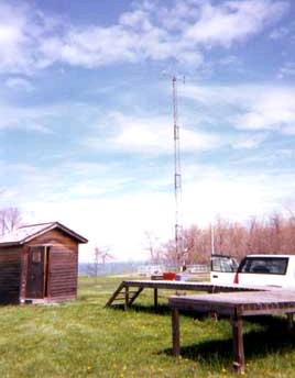
Sturgeon Point is located on the southeastern shore of Lake Erie in the town of Hamburg, NY (pop. 10,442). The site is about 50 km south of Niagara Falls and about 25 km south of Buffalo (pop. 328,123). Because of its proximity to the Buffalo area, Sturgeon Point does not meet all of the IADN siting criteria for Master Stations. Master Stations should ideally be at least 40 km from areas of more than 10,000 inhabitants, heavy industry or other major sources of air pollutants. However, considerable development exists along the Lake Erie shorefront. Sturgeon Point was the best compromise site for the U.S. side of the lake.
The site is located in a grassy area at the Erie County Water Authority’s Sturgeon Point intake plant. It is in an open field approximately 100 meters from the lake. Access is by a paved plant road used only by plant employees.
The surrounding area contains a mix of residential, agricultural, and commercial development with no sources other than the intake plant closer than one km to the site. The residential development is very light, and most of the livestock in the immediate area are resident-owned horses. There is a small agricultural field about one km south of the site.
About two km south of the site is Route 5, a roadway utilized by commuters who work in Buffalo. Major sources within 40 km include a large power plant about 20 km southwest at Dunkirk, NY, the New York Throughway (Interstate 90) 10 km to the south, and numerous steel and chemical industry source about 20 km to the northeast in Lackawanna, NY. The city of Buffalo also has many urban and industrial sources.
- Location
- 42.69306, -79.05500
- Elevation
- 176 meters
- Operating Years
- 1991 —
- Equipment
- Organic high volume (HiVol) air samplers
- MIC precipitation samplers
- meteorological tower


