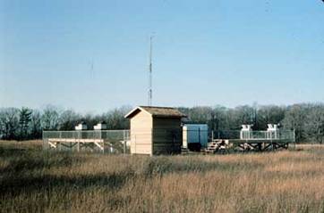
Sleeping Bear Dunes is located on the eastern side of Lake Michigan, approximately 150 km east of Green Bay, Wisconsin, and about 257 km north of Grand Rapids, MI. The sampling site is about five km south of Empire, MI (pop. 400) and one km west of Michigan Rt. 22, a major two-lane state highway. It is part of Sleeping Bear Dunes National Lakeshore, operated by the National Park Service.
The site is in an abandoned farm field on a secondary dune about 100 meters above and one km east of the lake. The shallow sandy soil supports a mixture of grasses and weeds, with scattered trees starting to take hold. About 150 meters from the site, a wooded hill of mixed hardwoods slopes down to Lake Michigan. The horizontal distance to the lake shore from the site is about 1.5 km. There are two homes within one km. The surrounding area contains woods, abandoned farms, fruit orchards, some agriculture, and some homes and summer cottages. It receives moderate use during the tourist season (May through October) and light use at other times. The closest urban area is Traverse City, MI, about 50 km to the east. Traverse City has some light industry and the usual mix of urban sources, such as vehicular traffic.
- Location
- 44.76111, -86.05861
- Elevation
- 241 meters
- Operating Years
- 1991 —
- Equipment
- Organic high volume (HiVol) air samplers
- MIC precipitation samplers
- meteorological tower


